John Bregar, whom I had climbed with last November on
Boyer's Chute had mentioned that he would be up for coming down to Las Cruces again this spring to attempt Squaretop with me. Squatetop has been a goal of mine for a while, ever since I attempted in in January 2006 and was thwarted by the snow-covered slabs at the entrance to the Squaretop gully. While this winter has been particularly snowy for the Organs, the route appeared to be pretty dry and John contacted me saying he could come down this week-end to make an attempt. He picked me up at 7am and we were off. Below is a blow-by-blow of the trip. for a shorter version, see the description on
Mountain Project.
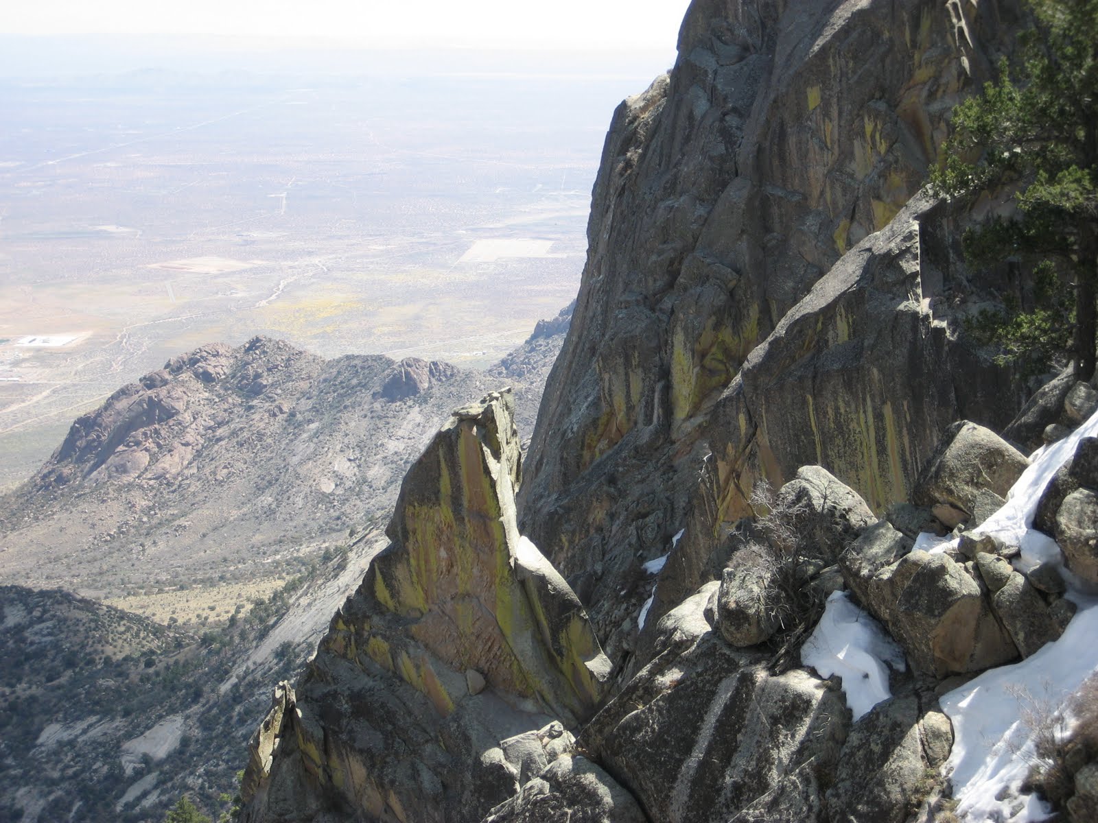
We made short work of the approach, using the familiar trail up to the tooth and then traversing south through some brushy terrain to reach the base of the Squaretop gully. This gully is protected by a 250 ft slabby section, that is steep enough to merit attention. There are weaknesses on either side, I opted for the left side which was more direct. John took the right hand side which looked more gentle. As it turned out, the right hand side got pretty steep near the top, steep enough where we almost considered having a rope. I helped John unlock a small series of ledges and holds on the right-hand side which while not difficult, were exposed enough over a clean 100 ft slabby drop to merit caution.
Entrance Slabs
Above this slab the gully became pretty choked with Apache plume, scrub oak and yucca. We pushed our way up slowly. Sometimes we'd cling to the left hand side and find some respite on the rock, only to be thwarted a few dozen feet higher by dense shrub. then we'd move to the other side. I checekd ingraham's guide which recommends to follow "deer trails" in this gully. Maybe the organ mountain deer population was higher in his day, but deer trails we found not. We grunted and shoved our way up, looking for the top where we were supposed to find "three gullies". Turns out, this was pretty accurate. We passed one gully on the right early, and wondered for a minute if this was to count as one of the 3 gullies, but once we got higher up it became immediately apparent; the main gully stayed brushy and trended left. In the middle was a clean rocky gully, and to the right was a pine-tree studded gully. We took a pause at the base of the middle gully to put on our harnesses as the top of this gully appeared steep.


Looking up the middle gully. John gearing up at the base of the gully.
Since we were all geared up, we opted to simul-climb the gully in case the going got steep, with me in lead. The gully had immaculate rock, perfect for scrambling up, and with hardly any loose or chossy stuff. The slabby wall to the right was gorgeous and would be worth making a trip back to put some lines up, despite it not being too tall. As I scrambled up it began to get steep, enough so where I had to pause and think about where to put my hands and feet. About 120m up, I reached a nice ledge, to the left was a way to gain the ridge-top by crawling underneath a huge boulder, to the right was a steep headwall continuation of the gully we were climbing. I was pretty sure we were to continue up the headwall, but I wanted to check out the ridge to the left, so I belayed John up to this ledge. Scrambling over to the ridge involved crawling underneath a giant boulder, with barely shoulder room to crawl through. As I was attempting to worm into this spot, a giant boulder i was stemming off of wiggled loose. It didn't fall, but it was loose enough and in a weird enough position where I decided to abandon crawling underneath the boulder.
Turning our attention to the gully's headwall, it looked steep, Enough so where I had John belay me from the ledge and even placed a few pieces of protection. There weren't any hard moves, but a slip would send us tumbling down for hundreds of feet so we played it safe. I belayed John up to a grassy brushy area underneath the main Squaretop cog and with a nice view of the S-1 spur. the spur was supposedly only 4th class to its top, but looked more like 5th to us. Only the week-end before I was debating
John checking out the S-1 Spur
The S-1 spur was dwarfed by the over-hanging summit cog of Squaretop. There were some cracks up this face that might me climbable, but not by me. We followed the brushy ledge around the summit cog and climbed up and easy 3rd class open book, passing under a giant boulder to reach the saddle.
John climbing out from underneath the boulder-saddle
We ate lunch at the saddle and admired the view; the Tigerfang was right below us begging to be climbed, the North/East sides of LST/LSTM also showed themselves to us. I was contemplating a traverse over to these peaks. It must be doable, but I could not see the whole route. There were too many jagged spurs between us and those peaks. However, it would be a nice goal to come back and climb Sqauretop, and then continue over to the LSTM area and down the regular Organ Needle trail. Or why stop there? we could continue up the Needle's NW ridge and bag all 4 summits. Maybe next time.
Looking down on Tigerfang from the ST saddle
Checking out the final pitch up Squaretop, we both agreed that we'd want to be roped. It alos appeared to be harder than 4th class, although there is certainly room for debate on this. My theory is that back in the 50s, rock pitches like this were climbed with ropes and protection, but if the overall angle was not too steep, they were still deemed 4th class. By "modern" standards, this pitch seems to fit a low 5th class rating, being as steep as other 5.3 and 5.5s in the Organs. And steepness aside the starting move did not look trivial; it looked like we'd have to stem into a corner underneath a small overhang, and then hand-traverse out right until we could mantle up onto easier territory. the traversing over though exposed one to a big 40ft drop over the east-side gully. Not exactly something that we were willing to try un-roped.

the crux move started in the shadowed corner and traversed on the crack out right until you could step up. Due to hidden edges and holds, it's easier than it looks.
In the crux-corner, we found an old piton for protection. Cams/wires also fit, but I still clipped the piton as a back-up.
I led up the last pitch which was indeed easier than it looked, despite being exposed. Above the crux move, there were good crack systems and a gentle angle making it a cruise to the top (time ~130 pm). We didn't stay on the top long, taking a few pictures and replacing the summit register. The old register was in a pill-container and was only two pieces of paper, with 4 recorded ascents going back to 1996. There was also some broken glass from an old jar. no doubt the previous register was already swapped out years ago, or perhaps was destroyed when the glass container broke.
 << summit register and broken glass
We found poot slings at the top for a rappel, but they were probably as old as the last recorded ascent in 2001, and looked pretty beaten up, so we swapped them out for some new webbing. Our single 60m rope got us down to the saddle without a problem. We then down-climbed the 3rd class open-book and walked down to the top of the 4th class gully. The rappel anchor we found at the top of this gully was an old piton and a giant tangle of mangy webbing. At first I thought that the piton was the only anchor point, but buried in the nest of webbing was an old wired hex. By cutting away all the old webbing, we were able to create a two-point anchor using the hex.
Cool old-style hex. I was tempted to keep it as a souvenir
The rest of the descent was pretty straightforward. We rapped another rope-length down the rock-gully and then down-climbed the rest of the gully. Bush-whacking down went quickly and we rapped the entrance slabs off of a gnarly juniper snag. I used up all 25ft of brand new 5/8" webbing that I had just ordered from REI. I should have order a bunch more, we had to replace the webbing on every rap-station we used. I also should have brought more water, my single 3-L camel back was empty before we reached the car at 530pm and I was feeling dehydrated and beat. Lesson learned right? despite feeling totally exhausted and dehydrated, Liz dragged me out to a barbaque at our friend Matt's house where he fed me Oryx burger and made me feel all good again. Thanks Liz.
One of the most interesting aspects to this route was how to grade it. Ingraham describes the last pitch as high 4th, and all the earlier stuff only 3rd class or easier. This felt sand-bagged to me, but is starting to feel kind of consistent to some of the other old 3rd and 4th class routes described by Ingraham. I'm, beginning to think that the definitions used for 4/5th class back in the 60s were a little different from what is now used. And that grades such as 5.3 didn't even really exist. I'm guessing that anything below 5.5 was simply called 4th class in those days, and there is some logic to this. This kind of grade does not demand much technical skill, and many modern day climbers walk right up these climbs. But there is also a point where roping up on this grade makes sense, where the fall potential is serious and real. I bet even back in Ingraham's day they roped up for the same pitches that John and I roped up for. John and I both found this interesting to discuss as we climbed this route.