Thursday, June 30, 2011

Third Peak Summit Register


On a lot of the "minor" Organ mountain summits, I cannot find an old summit register. I was pleasantly surprised when I found this old film cannister on the top of 3rd Peak back in May. The 3 tiny sheets of paper in it date back to the 50s. Nothing more recent than 1972, wow!


Little Squaretop Summit Register

I retrieved the summit register from Little Squaretop back on May 13th 2011. There was an old metal kodak film cannister tucked inside a newer plastic container. The old container had a sheet which had been recopied from a previous register, but it had information dating back to the first ascent parties in the 50s. always cool to read that old stuff.

Middle Rabbit Ear Summit Register

I retrieved the old summit register from Middle Rabbit Ear May 21st, 2011. It consisted of a PVC tube. The contents were not in good shape, and haven't been since 2007 when i first found it. I left some fresh paper (our route description) in order to sign, because the only other stuff in the tube was a moldy, wadded up piece of "paper" crammed in the bottom. I wasn't able to decipher much from this old sheet of paper, but what I could decipher is transcribed below. I plan on placing a copy of this transcription back up on the summit this weekend.


Friday, June 24, 2011

Sugarloaf: Simul-climbing with Jon Tylka

I've been going strong the last 5 week-ends, piecing together portions of the Organ-peaks-linkup, and this weekend was to be a break from that. Jon and I are going to try our big day next weekend. So instead of climbing or scrambling along the Organ Needles, we struck out for Sugarloaf today. We went to have fun and practice using my brand-new set of half-ropes, which we'll be taking with us for our big day. After some previous weekend trips, we decided two ropes were necessary and I was leaning towards getting a new rope anyways, so I bit the bullet and ordered a set of 8.1mm half ropes. Sugarloaf was our proving ground.

A few other OMTRS climbers, Bob Cort, Marta Reece, Matt Wotford and Cat Wu, were also wanting to climb Sugarloaf so we decided to head out as a big group. Once again, Eddie South agreed to let us in the BLM gate early, and we met him promptly at 5am to be let in. It was forecast to be a hot day, and it felt hot even at 5am. We spent a little while gearing up but were soon on the trailhead and flying up the trail. It took us 1h20m to reach the base of North Face route. Jon and I stopped here, planning to simul-climb this route first and then try another route later in the day. The other two parties had their sights on the Left Eyebrow and continued up a little bit further to the base of their route.

Instead of the light alpine rack Jon was used to seeing me bring, I had a full compliment of cams and nuts, and loads of runners. We discussed simul climbing details before starting up, such items as good communication, keeping solid pieces between climbers, and clipping both ropes through each piece (using them as twins). this last item is important because while simul climbing you cannot feed the ropes at different speeds, so they both need to move together. I racked up first and started up the immense and beautiful slabs, still in the morning shade.
Jon cruising up the North face
We made a steady and good pace up the route. I paused a bit at a slabby run-out variation on the "3rd" pitch, clipping both 1/4" bolts along this section. For the most part, simul climbing is about being comfortable and confident on the rock, climbing fluidly together. After a little while, my world narrowed to a focus of climbing movements. Eyes darting to each good hand and foothold, stepping up and feeling for slack or tension in the rope, and always moving upward. I ran out of gear a little over half way up the route, on the huge grassy ledge. I set an anchor, but Jon on belay and brought him up quickly. He already had most of the gear with him, but I gave him the remainder and tried my best to point out the route for him to lead us to the top. "It goes right to that block," I pointed. He nodded and agreed, and then proceeded to climb straight up well left of the normal route. I reminded him a few times that he was off route left, but he was already on his way. That's one of the beautiful things about leading, is you can pick your own way, travel up whatever looks best to you. In this case, it meant a little dirtier climbing, more lichen covered sections, and some loose rocks, but overall decent climbing. Jon eventually met up with the normal route near the upper pitches, and when i reached him at the top he was all smiles.
Jon tossing the rope for the east side rappel
Our ascent had taken 2 hours, it was about 9:30. We rested a bit on the top and then talked about the descent. I have always rappelled down the south side, but we had noticed a newish looking suing on the East side and decided to give this descent a try. We were able to scramble lower than this first sling to another rappel station, and set up the ropes for a double-roped descent. I went first, sliding quickly down the two brand-new half ropes. 60m put us on a large ledge where there was a single 1/4" bolt rappel point. It looked to be in decent shape and we were sure to be able to reach the ground from there, so we pulled the ropes, only to get one of them stuck. The orange rope had caught on a flake and was not budging. We tried all manner of flipping the ropes and gently tugging, but I was worried about damaging my brand-new ropes, so I had Jon put me on belay on the purple rope, and I climbed up to free the stuck loop. Turns out it had wedged into a small flake and came out easily by hand. No harm done to the rope, I down-climbed back to jon and we set the 2nd rappel. This time Jon went first and immediately tacked right when he spotted a nest of climbers booty. He is still building his rack, and any gets super excited about finding climbing gear. Since he wanted to work on cleaning the two wires and tricam (plus 5 carabiners), I went ahead and rappelled down. Attached to the booty-anchor was a ratty old rope, sheath completely missing and totally coming apart. I tugged it down while rappelling so that we could trash it.
Bottom of 2nd rappel on East side
Jon was successful in cleaning one nut and the tricam, but couldn't get the last nut. Still a nice find, he was over the moon about it. We packed up the ropes and scrambled down the east side gully of Sugarloaf. This area was pretty heavily burned out by the recent Abrams Fire, and there were some large felled trees as well. some sections require a bit of down-climbing finness but overall it was a decent route. Still, after getting a stuck rope, my preference lies with the cleaner South side rappel route.

Our decent had taken nearly two hours, almost the same amount of time as climbing the route. Still, there was plenty of time to get on another climb, and the other two parties could still be seen high up on the mountain. We rested a bit, and refilled our water from the generous water cache the Bob and Jon had hiked up last Wednesday. I can't stress how utterly awesome it was to have 4 gallons of water here at the base of the cliff for us. I'm sure we all could have done with just our own water, but we were in oh so much better shape with it. Despite the heat, I was feeling good, not fatigued at all.

For our next route we were both interested in the hard slab route, Science Friction. We made our way up to the base of it, and stared up at the intimidating blankness. Unlike the North Face route, this one is steep slab, thin 5.10 moves between widely spaced bolts.It didn't take me long to balk at leading it. I told Jon I'd belay him, but didn't think I was up for leading. He was seriously tempted still, but ultimately decided that he wouldn't want to fall on the initial pitons. Our eyes then turned to the large right facing corner just to the left. My topo called this 5.8 corner Banana Peel, it didn't look easy. 
Attractive right-facing corner of Banana Peel
The right leaning corner looked like a powerful layback climb, with almost no feet or rest stances. Jon though was game for it, and racked up. This time we decided not to simul climb, letting Jon place as much gear as needed, and use the half-ropes as they are intended, clipping either rope as needed to reduce rope drag. This worked beautifully, as seen in the picture below.
Half-rope technique displayed, on Banana Peel
Jon muscled up the layback, and looked to me to be confidently sailing the route. Right above a small rest-stance, he dropped the set of nuts while trying to place them, and by some lucky break they stopped short in a flake just below him. He was able to retrieve them and continue up. He did appear a bit nervous in one section and took a rest at a stance above to recover. I discovered why on seconding, the layback was committing and draining. There were some good stances though that couldn't be seen from the ground, the key is all in the footwork. But even with good footwork, placing gear from the layback position is strenuous and I can see how he could get a pump trying to work in a piece. At the crux section, a fixed cam was overcammed way back int the crack. Jon had clipped it, but it was difficult to even clip because the wire-;loop was deep in the crack. This is where Jon had exerted the most effort, and I could certainly understand what was going through his head on lead. Above the crux section the climbing got a bit easier, but it also worked over this hollow huge hollow sounding flake. Easily a couple body-widths across, it resonated with each step I took on it. It didn't appear to be in danger of falling, but that ringing boom is enough to make anyone nervous.

At the top, Jon had set his belay right at the corner of the ;edge, but there was a bolted belay 20 ft back and at a better stance so I went straight for that, and then pulled the rope over to me. Since the rope was then stack for Jon to climb again he took the next lead. We decided to get back to simul climbing, the corner above us looked very easy, and then it joined right up with the Left Eyebrow. Matt and Cat were still high up on the route, and we exchanged a few hollers before heading up.
Easy middle pitches of Left Eyebrow Route
Jon made it all the way up to the large dead tree beneath the crux pitch, but a poorly planned gear placement had left him with terrible rope drag and he decided to set up his belay there. I racked up at the tree and got to lead the high quality upper pitches. The only other time I had climbed this route was with John Hymer years ago, and again we had simul-climbed it. I didn't really remember the route, but had a good enough idea. plus a fresh trail of chalked holds had been left by the party above, so i could always just follow their lead.

The exposed crux pitch was awesome, and as good as it gets for a 5.7 multi-pitch route. Probably 1000' above the floor, you swing out to a committing move around a roof/prow, not being able to see what's on the other side. You can swing your feet and out, and yelp away, then pull over and find bomber jugs to haul up on. really a stellar feeling, maybe even the best move on all of Sugarloaf. Above this move the climbing stays interesting, with run-out slabs, gneiss intrusions dotting the rock and providng holds, and the opccasional old 1/4" bolt. I took my time threading through the terrain, searching out the best rock and most protectable features. I also made sure to holler back down to Jon to make sure he let me know when he reached the crux moves. I knew he wouldn't have a problem with them, but I also wanted to make sure I had a decent stance when he got to this section. With simul-limbing, communication is key to avoiding sticky and uncomfortable climbing.

I reached the summit just a minute behind Cat. 10 minutes later bob Cort came into view atop the north face route. He and Marta had heard Matt complaining about a loose pitch on the Left Eyebrow, and decided to switch over to the North Face route at the large ledge. The timing was perfect, with all six of us on top together. It was around 3:00pm, it had taken us a little over 2 hours to climb another route on Sugarloaf. Once agian I forgot to birng up a proper summit register, but thanks to a geocache on the summit, I left a make-shift tiny register in the summit cairn. It should last 6-12 months, by which time maybe I will be back to put a proper log-book up here.
Myself and Jon, with the ridge-line we hope to conquer in the background
After the requisite summit tom-foolery, we set-up a fixed line down to the South rappel. With 6 people and 4 ropes, we made good time setting rappels and getting down. Once again we all refilled our water and drank the last of the 4 gallons of water. We took a leisurely pace on the hike out, making it back to the cars by 7:30pm. Bob had a cooler of ice cold water and beer waiting for us, now that's what I call prepared!
Left to right, Top: Jon, Cat, Marta, Matt. Bottom Aaron, Bob

Saturday, June 18, 2011

Last Peak, Nordspitz and Baylor Pass

The North rabbit Ear looms behind a yucca from the summit of Last Peak
I reached a special milestone today. Ever since we moved to Las Cruces, I have wanted to climb up all of those jagged peaks on our horizon. Today I reached the summit of the last two. Well, to clarify, the last two of the jagged "needles". I still haven't been on Baylor Peak, or even Organ Peak (restricted are). No matter, I am happy anyways. Reaching these last two peaks also gives me a little more confidence about the upcoming Organ peak Marathon. I have a basic familiarity with all the peaks on our route, ways to get up and down, information which is key to our attempt to link all of these peaks in a single day.

My hike today started before the sun came up. I bade my sleeping family a quiet "goodbye-morning" and jumped in the car around 5am. I parked at my usual spot a mile or so up the Topp Hut road, and started hiking up. I decided not to bring any climbing gear with me, but my pack was still heavy because I was carrying an extra 4 liters of water to cache. I was also solo today, Marta and Jon had decided to team up and hike up the Organ Needle and familiarize themselves with the northward route from their (they made it all the way to Lost Peak). Being solo is nice sometimes, and I took a several extra geocaching diversions on my way up.

The hike in was nice and cool, and stayed cool all the way through Rabbit Ears Canyon. There was an unfound geocache on top of the Citadel which I decided to go for. I dropped my heavy pack in the canyon and took a 30 minute detour to grab it; Normally, the Citadel can only be topped out by 5th class routes, but I was pretty sure I could find a scramble up it. I remembered a hidden gully to the west of the route Wish You were Here, which was an easy scramble. It topped out on a large shoulder a few pitches up on the West Ridge. This left me with a little bit of  exposed climbing, but after looking at it carefully, I was confident I could get up it. I did have a few second thoughts about coming back down. After all, I had no rope or gear to rappel with. Pushing those thoughts aside I summited anyways, thinking there was probably another descent/scramble on the south side. I did find nice rappel chains on the SE side side of the summit, but no easy scramble down. However, down-climbing wasn't as bad as I had feared and I was soon back down to my pack, and on my way up to Last Peak.

My approach was up the main gully on coming down from the north end of North Rabbit Ear. About half way up a rocky ridge divides the gully. I had been up the right-hand side before, on a previous trip up to the CWM, so I decided to try the left-hand side this time. It had a few sections of tough bushwhacking, but was pretty easy and direct. I was soon up to the saddle between the CWM and Last Peak. I stashed 2 liters of water and scoped out the potential routes up Last Peak. There was a promising route right up the south face that I was interested in. I could see a way to scramble up some ramp systems to a shoulder mid-way up the face. from here I could only see a 5th class corner to the top, but the rock around the corner was hidden from view and I was thinking that it might have a scrambleable gully. I decided to have a look. The initial "scramble" section involved a 5th class move, and once again I worried about reversing it. Still, I went up hopeful for the nice gully around the corner. I got up to the shoulder and looked around the corner, and was dismayed. Not only was there not an easy corner, but it was actually steeper over there. right above me though, was a very attractive route up a narrow rib. It looked in the 5.6-5.8 range, but there was no way I was going to solo it. Lucky for me, I did not have to reverse the hard move I had done to get up here, instead finding a secure (but 5th class) down climb in a crack system with good holds. Safely back at the saddle I made my way west around the base of the wall to look for the regular route up.
South Face of Last Peak, and my aborted route attempt
Only a few hundred feet away was the 4th class (3rd class Ingraham) route, up a nice weakness to the top. I quickly ascended and was on the lovely summit ramp in no time.
4th class route up Last Peak
I found a small summit register left by a recent Geocacher, and added my name to it. The log was only a single sheet of paper, so I think I'll bring up a proper notebook when we come here next. It was still early in the morning, so I found a nice spot to sit and eat breakfast. I had birds-eye view of the summit of The Citadel where I just was an hour ago. I took my boots off and let my feet air out, munching on trail mix and gulping water.
Dry feet are happy feet
Agave blossom/fruit on summit of Last Peak
After a suitable rest, I peered over the north side of the peak to scope out the descent down to Nordspitz. A jagged ridge led directly towards the saddle. There were a few spots that looked like they might be difficult to negotiate, but overall it looked doable and direct. I started down the exposed ridge-line, carefully climbing over blocks and down boulders. About half-way down I was stopped by a steep section. It would be a short and easy rappel (although I saw no rappel gear from previous parties), but I had no rope. However, there was a weakness on the east side which i thought I could down climb and I decided to go for it. I had to be extremely careful here, using the crack for solid jams and carefully placing my feet and testing the rock as I lowered myself down. It was indeed down-climbable but when Jon and I come back this way on our big traverse, I think we'd be better off rappelling.
Looking down the North Ridge of Last Peak
Getting up Norspitz was a cinch, a simple 3rd class scramble up the south side. There was another new register placed by the same Geocacher. I looked around for signs of an older one, but didn't find anything. It's pretty unlikely that this peak sees many ascents anyways.
Summit shot on Nordspitz
I didn't stay on the summit long, and started scrambling down the North side of the peak. The scramble off was nice, over some beautiful slabs and past some nice old trees. I had to zig zag a bit to avoid a large steep wall, but it was all very straightforward and actually quite pleasant. Minimal brush-beating, not too much slippery gravel, and slightly shady from the North-facing aspect. When i finally got to the bottom and looked back up, Nordspitz actually looked like quite a nice peak, with gently slabs growing up into a nice little summit. It would probably be a nice hike to come up this way from Baylor pass, but my goal today was to do the opposite.
North Side of Nordspitz
The first 1/4mile along the ridge towards Baylor was the worst of the bushwhacking. I delicately threaded myself through mahogany, cholla and yucca, eventually reaching a small summit. From there it was a bit easier although still brushy. There were occasional faint traces of "trail" and I was before I knew it I was down at Baylor pass. I cached another 2 liters of water under a shrub, and pondered my next move. Getting back to my car on the Topp Hut road would take some doing, I could go back the way I came but what fun would that be? Another route I considered is a sort of ridge-line which goes from the top of the Lambda to somewhere near the pass. Ultimately though, I opted for a lower elevation route, skirting around the base of the some unnamed cliffs. Partially this was motivated by a few more geocaches, which I picked off lower down, but I also was interested in checking out the impressive cliffs on the North side of the Lambda Wall massif. I've often stared at these cliffs while driving along Baylor road. There are some obvious corner systems which beg to be climbed, and I was interested in some reconnaissance.
All smiles before I left Baylor Pass trail
I left the Baylor Pass trail a little bit below the camping spot, and aimed for a small pass to the south.from there I was able to scramble over maintaining my elevation to another little pass, overlooking the canyon beneath the unnamed wall. So far the brush hadn't been very bad, but I could see that traversing around the base of this wall was going to be tough. The steep slope beneath the wall was boulder-strewn and choked with vegetation. I didn't see any possible easy route, so just forged ahead trying to maintain some elevation. I got a good look at the corner systems, they look like they could be really awesome routes. The approach from Baylor Pass would be reasonable, although it would be better in the cooler months.
Unnamed Cliffs North of Lambda Wall
My water was running low, it was the hottest part of the day and I was in the worst terrain the Organs can throw at you. It seemed like forever, but I finally rounded the corner underneath the Lambda Wall, and made my way back into Rabbit Ears Canyon. To my surprise there were hikers there, two guys coming down from Rabbit Ear Massif. they had just passed by the campground and lost the trail. I helped them get back on track, and then hiked out with them. One of the guys, Andre, actually grew up near the Gunks, and went to school at Plymouth State, right near where my Dad lives in NH. Small world. I enjoyed the company for the last hike out, we commiserated about our lack of water, and the hostile Organ mountain plants, and cruised back down the Topp Hut road. Overall route stats: Hike came in around 10.8 miles with a total elevation gain of about 2500 ft. Car-to-car in about 9 hours.
Hot and hazy looking South-East from the Nordspitz

Sunday, June 12, 2011

Traverse of the Low Horns


 This week-end's Organ Mountain challenge was to complete what we had set out to do last week-end, namely traverse the low horns from #6 through #1. This time it was just Jon and me. We got an early start thanks to meeting th BLM host Eddie South, who met us at the Aguirre Springs gate a little after 6am, and let us through. Starting up the Pine tree Trail early makes a huge difference. Most of our elevation gain is getting up the ridge-top, and the cooler monring temps definitely helped us not sweat our brains out. We reached the saddle between Horn #6 and The Spire a little after 8am. We left another water stash to lighten our load.
Jon at the high-point of our aborted route on the S face of #6
While I was pretty sure we'd end up scrambling around the west side of the base of Horn #6, in search of the normal route up, we had made good time and after gazing at the south face Horn #6, decided we'd try a route. A series of cracks and ledges seemed possible, so I racked up and started up. Only about 40ft up, I ran into a crux move where the wall got steeper and there was an awkward pull up into a thin corner. I approached the move from a few different angles, but ultimately decided I wasn't up for it. Maybe the extra weight of the pack worried me, or my lack of much recent climbing... either way, I balked. Jon wanted to give it a go though, so I left my high piece in and down climbed. When Jon got up to the high-piece, I was sure he would get passed. He pulled up on the hard move, and was almost established in the corner, where easier climbing lay ahead. but then he too chose to back down. He was able to clean the gear while down-climbing.
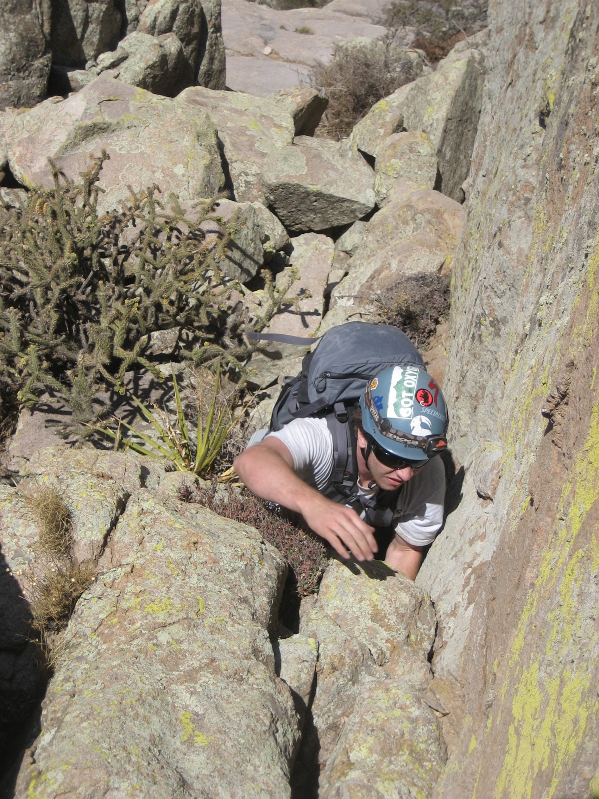
Jon on the sketchy slab traverse
Thus thwarted, we scrambled to the west around the base of Low horn #6. The west side was still shady and cool, which felt great. We dropped a bit of elevation, but were then able to traverse across a smooth slab and get into the gully which leads up to the saddle between #5 and #6. I made it up there first (Jon thought the slab traverse was SKETCH) and relaxed a bit, checking out the potential routes. When Jon reached the saddle, he realized that his water bottle had become unclipped somewhere between us and the Spire saddle. Since I was all rested up, I volunteered to scramble back over and look for it. I took a different slightly better traverse of the slab this time, and found the water bottle right where Jon had though it might be. This ate up a little more time, but it was still early. The scramble up the north side of Low horn #6 was easy and clean. The summit was pretty large and we spent a little time searching for a summit register, but not finding one. I left a new register and we headed back down to the #5/#6 saddle. The time was 10am. On the way down we scoped out possible routes on #5.

The South flank of #5 did not appear to have a 4th class route up it. There was a short 5th class section to reach a shoulder, then a final headwall broken by what appeared to be a chimney. I was referring to the Ingraham description and was convinced an easier route must be around the corner. We scouted to the east side, but nothing looked easier there. To get around to the west, we would need to drop down in elevation again, and take a ledge north to unseen terrain. We put our packs back on and headed that way. Once we turned the corner, we were confronted with steep, blocky and dirty terrain leading up to the mini-saddle on the south side of #5. It looked scramble-able, and indeed it was, but it had a few scary moments for me. It was the kind of terrain that ends up being steeper than you expect, with less positive holds, and more exposure than you bargained for. Also, there was a lot of lichen, dirt and vegetation in the cracks. The only positive was that we were still in the shade, and it was nice and cool. We eventually made it up this section, but I don't think we'll go this way again.

Low Horn #6 as viewed from the NW along our route around #5

We roped up for the final chimney, and I took the lead. I was a little worried at first, as it was hard to tell if the chimney was wide enough to squeeze into, but it turned out to be perfect. I had to dangle my pack beneath me, but could comfortably put my back to one wall and climb up features on the other. A small crack on the left wall provided ample protection and I was soon at the top. I think this is probably Ingraham's Chimney Route, but I wouldn't call it 4th class, more like 5.6. Jon quickly joined me on the top and we spent a while relaxing and enjoying the summit. It was about 11:30am, and we still had a ways to go, but I was hoping the hardest climbing would be behind us.
Myself on the Summit of #5

After our nice rest, we loaded up the packs again and started scrambling north. We had been warned about several false summits, and indeed there seemed to be a few of these along the way, but we were able to scrable along the top of the ridge without much problem. We passed a new-looking rappel station closer to the northern flank, but didn't use it, down-climbing all the way down to the #4/#5 saddle.
Jon on the beautiful ridge-line north of #5
The rappel station Marta and I had used last Fall was still in good shape and we could clearly see it from the saddle. Climbing up to it didn't look too hard. There was one steep crack section near the bottom, which involved a little grunting but was quite manageable, and didn't pose a serious fall. We were able to 4th class all the way up to the top of #4, nabbing the rappel gear as we went.
Jon does the "grunt" move up the S Face of #4
We didn't hang out on #4 very long, just long enough to scope out the next peak. We down-climbed the same route that Marta and I had scrambled up. I left another water cache on the #3/#4 saddle. There appeared to be an exposed 4th class route up the south face of #3, but we decided to rope up for it just in case it was harder than expected. Jon took the lead this time, and made short work of the face.
Jon leading the S. Face of #3
It was indeed as easy as it looked, although Jon opted to make a few 5th class moves instead of taking an easier ledge system, which saved him from potential rope-drag issues.I quickly joined Jon on the knife-like summit of #3. There wasn't much room to hang out, and #2 is so close, so Jon looked for a down-climb while I coiled the rope. He found a good 4th class down-climb on the NW ridge, and before I was even finished with the rope he was on his way up #2.
Jon scrambling past the crux boulder problem of the S. Face of #2
The south face route up #2 is very straightforward. from the saddle, there is a single 10ft boulder problem move, and then it's easy scrambling up to the top. Marta and I had rappelled this section before, since there was already a rappel station available, but it could probably be done without a rappel. I caught up to Jon on the summit of #2, and he was already scoping out routes up the south face of #1. getting down the North side of #2 though didn't look trivial, but there is a good rappel station already there, so I broke out the rope and we made a 30m rappel down to the #1/#2 saddle.
Me showing off a cool geocache container on the top of the Horns
The time was 2:30, we were finally starting to pick up the pace over the last few horns. After scrutinizing #1's south face, we opted to scramble around to the east, and then up the easy 3rd class East Ridge. We topped out on #1 at 3:00, completing our run of the horns! Our water situation was pretty low, but we were both feeling good. Jon really wanted to "tag" Gertch since we were almost there already. I didn't really get this, Gertch doesn't even have a discernible summit. But we down-climbed #1 and went over there anyways, and lo and behold, found a "summit" register. It was only recently left in 2007, and was marked by a dead branch stuck in a pile of rocks. It was logged a few times by apparently the same group of hikers, always coming up from Aguirre springs. I never really thought of Gertch as a destination hike, but I guess it would be pretty fun.

From Gertch we made the brushy descent down to Big Windy Saddle. Marta had added to our water cache here, and I quickly found the bottles she had left, but it took a good search to find the original 2 quarts we had left. I had tucked it way under a rock so that it couldn't be seen from any angle. We decided to put it next to the other water bottles to make it easier to find. the time was now 4:00 and we were down to less than 1 liter of water between us. Still Jon wanted to press on and tag Rabbit Ears Massif, and maybe even the SRE. I knew this would cause us to run out of water. It was hot, and that is a long detour. There also wasn't much of a point in bagging those peaks either, we know the way up them already, and Jon had already tagged the SRE. Still, there is a certain appeal to being "hardcore" and pushing ourselves. Against my better judgement, we started off towards the Rabbit Ears.
View South from Big Windy (#1 flank in back-ground)
We made good time getting to the top of Rabbit Ear Canyon, but it was still very hot and we used up almost all our remaining water. We dropped packs at the saddle there, and scrambled light up to Rabbit Ear Massif. There is a geocache up there that I was hoping might have a little stash of water, but no luck. Just the regular Geocaching type knick-knacks. We scrambled back down, put on our packs and started over to SRE. It actually made sense to go to the SRE/MRE saddle and then descend to Aguirre, rather than try to go back to Big Windy and descend. I've never done this descent before but Marta has mentioned several times that it is her preferred trail to the summit of SRE, and it would probably save us time. in getting over to the SRE saddle, I got ahead of Jon and lost sight of him. I found a shady spot on the saddle and waited and waited, trying to resist drinking my last ounce of water. When he didn't show up, I started to worry. I dropped my pack and started back down the SRE west gully, calling out for Jon.  Eventually I got a reply, from way over at the NRE/MRE gully. He had somehow missed the SRE gully and traversed too far north. Serves me right for not sticking close, but I still wonder how he could have missed the SRE gully. We weer here only a few weeks back...

The rest of the descent down the east side of the SRE gully we were dehydrated. our water was gone, and we were tired. At least it was shady though. The gully is mostly bare rock until it reaches the bottom of the SRE cliffs. I seemed to recall that it exited the gully down here, adn followed a ridge-line. I struck out on the wrong ridge-line for a short ways, but then we doubled back and found the correct ridge-line and a faint trail marked with cairns. We followed this trail all the way down, losing it only a few times near the bottom, where it meets up with the Baylor pass trail.
Happy to be back on Baylor trail, and almost to the car.
It was an exhausting day, we were back to the car at 7pm, making for a 13hr car-to-car trip. We were both a little dehydrated when we reached the car, but we also felt pretty good. Our speed over the Low Horns had been reasonable. The first two took the longest, and Jon nicknamed them the "Slow Horns". Now that we know the routes though, I think we'll be able to make good times across this entire section. Plus, we now have a few more water caches to help us along the way. A ver successful day!

Saturday, June 4, 2011

From Wildcat to the Spire

After linking up the Rabbit Ears, the next big question mark for me on Organ Ridge through-climb is between Wildcat and the Low Horns. We this in mind, Marta, Jon and I struck out to find a route through these peaks.
View from Pine tree Trail showing the "green ramp" between Dingleberry and Wildcat dead-center
We got to Aquirre Springs campground a little after 8am and ran into the BLM host. Eddie South is his name and he was kind enough to give us his phone number and allow us to call him to open the gate early should we want to do so in the future. What a champ! We quickly started hiking and opted to take the elusive Ghost Fire trail in hopes that it would save us some time. the Ghost Fire trail/canyon was first shown to me by Marta on our trip up the Wedge last fall, and is a nice shortcut to the middle of the Pine tree Trail. Marta made me lead, and I got it wrong in a couple of spots, but now I have a nice GPS track of the route.
jon digging the nice slabs on the approach 
Marta underneath Dingleberry
We took a short break at the top of the Pine tree Trail, Marta said she was not 100%. It was also a very hot and humid (by NM standards) day and I was sweating profusely. We ambled north along the Pine tree trail for a short ways before coming to the gully which leads up between Dingleberry and Wildcat. The first 1/4m or so up this gully was tough and nasty bush-whacking. Jon coined the term "narberries" to describe the thorny plants we had to get through during this part of the hike. It was reminiscent of my adventure on the Lost Carabiner route last year.
Jon and Marta nearing the top of our approach gully

Fortunately, the gully became steeper and more passable the further up we got. Near the base of Dingleberry's cliffs, we bore right up a beautiful slab, to get to a right leaning tree-filled ramp which leads up to the Wildcat-Dingleberry Saddle. The tree-filled ramp was pretty descent traveling, but near the top the brush got pretty thick again so we opted to scramble on rock to climbers right, and quickly gained the summit ridge of Wildcat.
Jon on the summit ridge of Wildcat
We did not stay on Wildcat for long, stopping only for some food and water. I left a ~2l water cache near the summit for future use. It was hard to tell what the best way up Razorback would be from our viewpoint on Wildcat, but there was an easy scramble to reach the saddle, so we decided to go check it out. The scramble down is on slightly to the NW, and while descending we found the easy SE Ramp route up to Razorbacks summit.
Jon Tylka at the top of the SE ramp
Razorback did not have an existing summit register that I could find, so I left a brand new one. Jon found a rappel station for the north side, and set up a double-rope rappel while Marta and I relaxed a bit.  The Spire's summit is incredibly close, and we had good opportunity to scout out routes up its southern wall. there was a huge ledge about half-way up that if we could get to would surely get us up to the top, but it was hard to gauge the lower pitch to get to this ledge. While waiting for my turn to rappel, I also scoped out the beautiful razor-sharp West ridge which gives Razorback its name. I was very tempted to hand-traverse out across it, it looks so inviting. I will definitely need to come back to climb this route some day.
Marta getting ready to rappel off of Razorback

We used two ropes for the rappel from the summit, my 60m and Marta's 50m 8mm rope. The 50m rope just barely reached a small ledge where Jon found a single bolt/quick-link. Fortunately, this was not one of the old rusty 1/4" bolts, but a newer looking 3/8" expansion bolt with a beefy metolius hanger. From this bolt it was another 20m rappel (just using Marta's 50m rope) to the saddle.
The namesake knife edge on the West Ridge
While the west gully between Wildcat and Razorback appeared very difficult to go up or down, the west gully between the Spire and Razorback looked walkable. We definitely had the option of hiking around the west side of the Spire and going up the Normal Route, but Jon was psyched to try a crack system on the South Face. this would give us a direct (and hopefully shorter) means of summiting the Spire when we go for our big day. We started the climb adjacent to a tree a hundred feet or so west from the saddle. Jon took the first lead and made it look easy, dropping into a hand-traverse at the identified crux-traverse. He stayed there a while to place pro, then mantled up and disappeared from sight, quickly reaching the large ledge. Marta struggled with the traverse on this pitch, trying to balance through it without dropping into a hand-traverse position. 
Marta starting out on P1 of the South Face route
At the large ledge, I swapped gear with Jon to lead the second pitch. It was less steep than the first, and involved a couple blocky sections between ledges. I chose a direct line at the back of the ledge, starting up a weird lay-back crack. What made it weird was that there was only 6-8" of rock to lay back against, and the threat of barn-dooring was real (this happened to Marta). this turned out to be the crux move, but was only a a few moves long so I did not end up having a problem with it. Above this the climbing was easier, but the rock was a little crumbly and there was also a large detached block that concerned be quite a bit. I warned Jon and Marta not to touch it much and finished up to the top.
Myself just before the crux layback
On the summit of The Spire
At the top, Jon posed for some "Deep Survival" photos. "deep Survival" is a book being passed around the OMTRS community about people surviving extreme conditions. the cover has a photo of a climber out on a rdige-top, with the rope making a gentle arc through space to him. It looks something like this:
Jon posing for a "Deep Survival" shot
According to the summit register I left here back in January, no one has been up here since then. We scrawled our names, then started the down-climb. I guided Jon and Marta down the way Dan and I had descended before. this involves some down-climbing of 4th class rock to reach an old rappel station about a rope-length from the summit. We did a single 30m rappel, angling west, and then down-climbed/scrambled the rest of the way down to the Spike, and then the saddle below. Some of the down-climbing along this route may be at the limits of 4th class scrambling, and Marta voiced her concerns more than once, but we made it down in one piece. It was little past 4pm and our next goal was Low Horn #5 & 6. Except I wasn't feeling it. Maybe it was the heat, or maybe it was a lack of energy coming from not eating enough. But I was feeling a little shaky, slightly nauseous, and not too eager to take on another unknown climb. I called Jon and Marta over to a shady spot so we could talk over our options. Jon was gung-ho eager to go, and offered me some gelatinous electrolyte. Marta was more neutral, saying she was good to keep going or head down. I was the one wanting to head down. I felt bad about being the weak link of the group, but I really didn't want to push myself too far and make myself miserable later on. We were at a good spot to descend between the Spire and Low Horn #6, and would get back to the car at a reasonable time. to me, it just made sense to "quit while I was ahead", but another side of me chided myself for being weak, and giving up to easily. How can I entertain ideas of linking every peak if I can't even push myself on a single day hike?

despite me feeling wimpy, both Jon and Marta were very gracious about calling it a day, and we headed down the rock-slide/gully back to Pine tree Trail. Of course, they did try to kill me once on the way down, by trundling enormous boulders at me, but that's another deal. By the time we got back to the car, i was feeling better, but glad we were down and headed home. despite not stringing together all the Low Horns, we still had a great day, discovering a new route up the South face of The Spire, and connecting over from Wildcat.